by Anthony (Tony) Marx
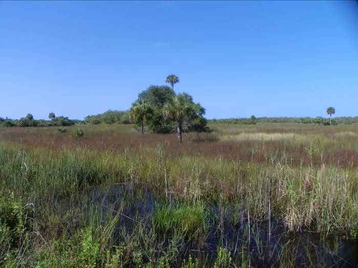
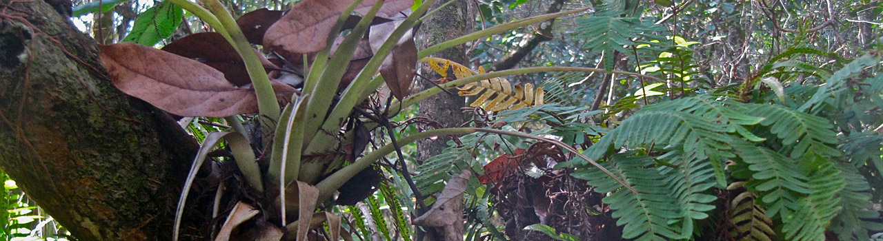
Photo taken by the author off Janes Scenic Drive.
The Fakahatchee Ecosystem is unique. Although part of the United States mainland, it contains plants that exist only within its borders (or very close by); others are found in the Caribbean, Central and South America. Many elements contribute to this delicate and fragile wilderness, each dependent on the other. Its preservation has enabled us to experience what much of South Florida looked like prior to the twentieth century.
South Florida has a sub-tropical climate, but the Fakahatchee Strand Preserve State Park itself actually enjoys a tropical climate within its depths. Thus, a mild temperature exists year round, slightly warmer in winter and slightly cooler in summer, perfect for the rare ferns, bromeliads and orchids that exist year round. Some are visible from the Boardwalk and on the hiking trails, while others only reward those who venture into the interior swamps off the trail, usually by joining a ranger-led swamp walk.
Much of the Fakahatchee is natural wetland, meaning it existed before man began altering its topography, but it includes uplands and aquatic systems, too. Seen from the air it presents a mosaic of contrasting colors. It includes sweeps of dun-colored upland prairie studded with contrasting green hammocks of tropical hardwood and clumps of pineland rooted on higher ground. The interior is a dark green forested swamp studded with stands of tall Royal Palms poking above the canopy. These are matched only by the occasional Bald Cypress which escaped the loggers attention sixty to a hundred years ago.
The ground slopes gently south, 2” to 4” per mile, quickly becoming wetter, with a central linear strand slough (wide, straight, shallow moving river) fed from two directions. Water enters the park from the north and flows south to disperse in the marshes south of US-41, and finally into the coastal mangroves. The depth ranges up to 6’ in summer, leaving a series of ponds that remain during the dry winter months. Theses provide the humidity needed for vegetation and a water source for the park’s wildlife. South of US-41, the wetlands consist of mostly open, saw grass prairie, with patches of marsh and swamp and shallow water courses navigable by kayak. Finally, mangroves herald the transition from brackish to saline, signaling proximity to the Gulf and home to the endangered American crocodile.
Although the Fakahatchee recovered from its period of logging from 1913 and reaching maximum output in the 1940s and 1950s, it is also partly an ‘Altered Ecosystem’. It is somewhat impacted by run-off from agricultural and ranchland to the north, its crucial water supply sources being the Okaloacoochee State Forest near Immokalee and the Caloosahatchee basin to the north-west. In both cases, before reaching the Park, the water flow competes with the needs of agricultural businesses and now the expanding development of Ave Maria and the huge planned city of Big Cypress stretching east from North Naples to Immokalee. Thankfully, during its progress through the Park, these pollutants are captured and absorbed by wetland plants, helping protect the crucially important spawning areas without which commercial and recreational fishing cannot survive.
The hiking trails and road access are all located in the northern half, starting at the Copeland ranger station, using the beds that were formerly logging rail tracks known as ‘trams’. The interior of the park is bisected by the dirt-surfaced Janes Scenic Drive, with hiking trails leading off it, elevated on what were originally the beds of trams hauling lumber out of the interior. These are the West and East Main, Mud Tram, and Uplands Trails. For those preferring a less strenuous introduction to the Park, the Boardwalk on US-41, located 7 miles west of the Everglades City Junction, offers enchanting views of the tropical forest and its wildlife, accompanied by newly-designed interpretive signs along its length.
The never-ending battle of conservationists versus developers will continue. The good news is that nearly 70% of Collier County is preserved under the jurisdiction of local, state, federal, and private management. More is being added on a regular basis, either by county and state government acquisition or private bequest. This is how the Fakahatchee State Park has expanded since 1974, when only a third of its present size at the outset.
At 85,000 acres it is the largest of Florida’s State Parks and is surrounded by protected and preserved land managed by other authorities. It is bounded on the north by the Florida Panther Preserve, and the Picayune State Forest adjoins its western side. The vast Big Cypress National Preserve is on its eastern side across State Road 29, and the Everglades National Park Ten Thousand Islands section is on its south-eastern corner.
Tony Marx is a Florida Master Naturalist and FOF Board Member. He is also a volunteer interpreter for the Fakahatchee guided tram tours and frequently contributes articles to The Ghost Writer.