Note: this article was written by the author in 2015 and updated by the Friends of Fakahatchee in 2022. For the current condition of Jones Grade trail that may become impassible, call the Fakahatchee park office 239-961-1925
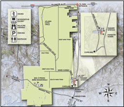 Nestled in the northeastern corner of the Fakahatchee and within the Preserve is a group of picturesque lakes formed from gravel pits that were dug during the building of Highway 75 known as Alligator Alley. The lakes are linked by berms which are rough but drivable if you have adequate clearance, or otherwise mountain bike or hike.
To access this area from HI-75 take Exit # 80 to take State Road 29 south. Proceed less than a quarter mile further south , and turn right onto the first unmarked gravel road, this is Jones Grade rd. on the map. No sign posted for this gravel road easliy missed but identified by a sturdy white mailbox with the name ‘Quaile’.
Approximately a half mile down Jones Grade gravel road, an opening appears on the right which affords a view of the lakes and where you will find a kiosk with information about this location in the Fakahatchee. Elevated berms divide the lakes and if you cross the first lakes, turn left (West) on the berm which ends at a rough dirt track, this track meanders north for a quarter mile ending at the wildlife underpass to cross under HI-75 even with traffic roaring overhead. It is not unusual to find a mix of panther, bear, bobcat and deer prints along this trail especially when muddy, and it is obviously one of the few opportunities for wildlife to continue north into the Panther Refuge and beyond.
Otherwise, continue to the end of Jones Grade at a gate, a mile from State Road 29. At this point the gravel road ends. The gate has a small warning sign prohibiting unauthorized entry and does not announce that it is an entrance to the Fakahatchee Preserve, which is why it is seldom visited except by Park personnel and the few private property owners along the road. There is only parking for about three vehicles on the right before the gate. There is a private driveway at the left of the gat, be careful not to block it or enter the private driveway, the owner keeps the entire road well maintained at his cost and we should be as un-intrusive as possible. I have parked at the lakes and biked down. However we are still entitled to enter the Preserve by walking or biking around the gate. Jones Grade now becomes a dirt double track with grass in between. Starting as a fairly easy trail to walk or bike, it gradually narrows and after 3 miles becomes rougher after reaching the junction with East Main which is seen on the map running south.
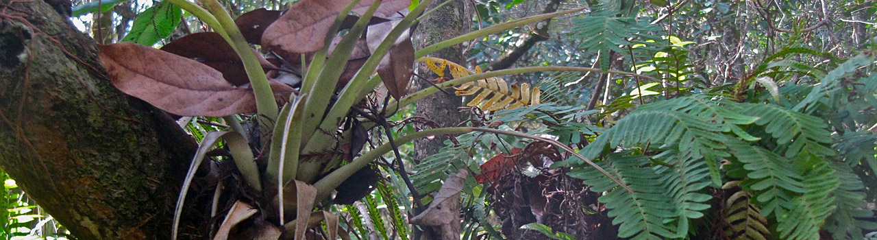
A quarter-mile past the gate the somewhat open trees and vegetation studded with cabbage palms gradually give way to taller cypress, pond apple, and other wetland trees and vegetation, while cabbage palms line the trail. There are no Royal Palms such as exist in the swamps farther south. The trail is elevated well above the surrounding forest base, and the ditch formed when dirt was used to build the berm has become a series of shallow ponds enclosed by sub-tropical trees and lush vegetation. It also is close to the Panther Refuge and tracks can be seen here and there. After a mile, a deep pond suddenly appears on the left and your arrival usually sparks a flurry of wings and splashes as Egrets and Herons rise with accompanying squawks, and perhaps an alligator disappears in a cloud of bubbles while a turtle or frog leaps from its perch on a fallen log.
The trees and vegetation now start to crowd to the edge of the trail and the tree cover extends above affording dappled or permanent shade; signaled by your GPS beeping a warning that it has lost satellite contact. This is when it is nice to have company, as you have entered a quiet and secluded environment where there is no sight or sound of human activity. The forest is silent except for a sudden splash, flutter of wings, a scamper of tiny feet and the occasional grunt of a pig frog. A hidden burst of heavy splashing or flight signals the escape of a larger unseen animal. After two miles several narrow and rocky water courses cross the trail, dry in winter and fordable in summer. In February – March a little farther on, fallen oranges in the trail announce the presence of a large wild orange tree growing next to the trail. This was once the northern spur of a logging tram line built to transport the cypress lumber felled nearby over 70 years ago and perhaps someone tossed away the remains of an orange which took root.
Because of partly hidden ponds both sides of the trail and especially if biking, keep watch ahead as you can come upon a basking alligator on the narrow trail. Usually they will move off when they see you but in mating season (February-April) a large male may be more aggressive and hold its ground no matter how much you wave your hands and stamp your feet. In which case keep a respectful distance and turn back. Otherwise continue on, and just under 3 miles from the gate you reach a ‘T’ junction. The left (south) trail becomes the northern end of the East Main Trail and continues 13 miles to gate 12 on Janes Scenic Drive, while the right (north) trail soon loops around to the west then loops south, marked on the map as Upland Hiking Trails and joins the western end of Janes Scenic Drive. Both these trails are navigable on foot between January and end of April, but are too rough and rutted to bike on.
For those seeking a little more adventure, unlikely to encounter another human being and uncertain of what you may meet, it is well worth a visit!
Anthony Marx is a Florida Master Naturalist and former FOF Board Member.